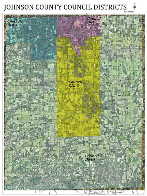
Two residents are challenging the Johnson County Council’s imbalanced districts, and the county has hired an Indianapolis law firm to evaluate and redraw the maps.
An attorney representing the two residents, Amanda Stevenson Holmes and Josh King, who are, respectively, the chair and vice-chair of the Johnson County Democratic Party, emailed the county’s attorney requesting the Johnson County Board of Commissioners take action to make the boundaries more balanced or they would sue.
The county commissioners on Monday hired Indianapolis law firm Kroger, Gardis and Regas to guide the county through the process of drawing legally sound district maps. Attorney Brian Bosma, the former speaker of the Indiana House of Representatives, will work with the commissioners during the process.
Stevenson-Holmes said Monday she and King do not plan to file a lawsuit at this time. They will participate in the process to redraw the boundaries, and are pleased to see the commissioners are taking their constitutional obligations seriously, she said.
The ideal population for each of the four single-member county council districts would be 40,441, representing a quarter of the county’s 161,765 residents each. However, the most populous district includes 45,610 residents, and the least populous has 37,706. Those districts are 12% greater than the mean and 7% less than the mean, respectively. The council’s total deviation is more than 19%, which is almost double the 10% standard deviation that is generally considered to be close enough to equal by standards established by state law for county council district boundaries.
The 10% standard has been used to apply the Equal Protection Clause of the 14th Amendment, which establishes equal voting rights and the one-person, one-vote standard. However, any district boundaries can be challenged if citizens feel the boundaries are not as equal as possible, Bosma told the commissioners.
The goal is to get the boundaries as close as possible to equal while staying within the statutory guidelines for council districts, Bosma said. Districts must be composed of contiguous territory, must be compact, must be as near as possible to equal population and may not cross precinct boundary lines. District boundaries should also avoid dividing townships, but may if it is necessary to achieve balanced district populations.
Another goal is to approve new boundaries as quickly as possible to avoid interruptions to the spring primary election. Because the four district seats are on the ballot this year, county officials are expediting the process. As a result, a process that would normally be done take 60 days will be done in 30, Bosma said.
The public can view the county’s redistricting guidelines in the commissioner’s office starting Thursday, and the plan is already available on the county’s website at co.johnson.in.us. The public may submit objections and written comments on the redistricting guidelines by Feb. 4, according to a legal advertisement set to publish on Thursday.
Bosma will work with Commissioner Brian Baird to prepare a new plan for redistricting by noon on Feb. 17. Members of the public may also present alternate district maps for the commissioners to consider by that deadline, the advertisement says. A map drawing tool is available on Common Cause Indiana’s website. Citizens used the tool to share alternate congressional district maps with state legislators during the state’s redistricting process last year.
On Feb. 22 at 10 a.m. The commissioners will have a public hearing on the plans for redistricting and will likely adopt an ordinance establishing new districts at 10 a.m. Feb. 22. Those who can’t attend the meeting can submit written comments by 9:30 a.m. that day, the advertisement says.


