


The proposed new Whiteland Town Council election district maps. The council has five members, and three live in and represent each different ward in the town.
Submitted photo
The Whiteland Town Council’s election district maps are expected to remain largely the same following the once-in-a-decade redistricting process.
The five-member council has three members who represent specific wards in town, while two members are at-large, representing the entire town. The three wards are split up by population and must be redistricted every 10 years, prior to the next election cycle, to account for population changes with the census.
Whiteland’s population increased by 10.3% in the last decade, from 4,169 in 2010 to 4,599 in 2020, according to census data. Ward 2, which encompasses the southwest section of town, saw the most population growth because new subdivisions built out in the area. Wards 1 and 3 saw less growth, with Ward 1 growing the least, said Stephen Watson, town attorney.
Because of the population changes in Ward 2, the population deviation between the districts on the current map would be over the 10% threshold that legal precedent shows districts should be under, Watson told the council during their July 12 meeting. Populations within election districts need to be roughly equal, and the ideal population for each of Whiteland’s three districts needed to be around 1,441, according to town documents.
In the new proposed map, the three wards are largely the same, with some of Ward 1 jutting out into Ward 2 at Main Street and U.S. 31, and also on the other side of U.S. 31, including some properties near Parkway Street. That would shift about 185 of the population out of Ward 2 into Ward 1, lowering the deviation.
Changes were also made to include land annexed into the town between 2010 and 2020. Land just north of Paul Hand Boulevard which is set to be used for industrial development was added to Ward 3. Also, a triangle shape of land west of Interstate 65 and just south of Tracy Road, where Mohr Logistics Park is now, was added to Ward 1.
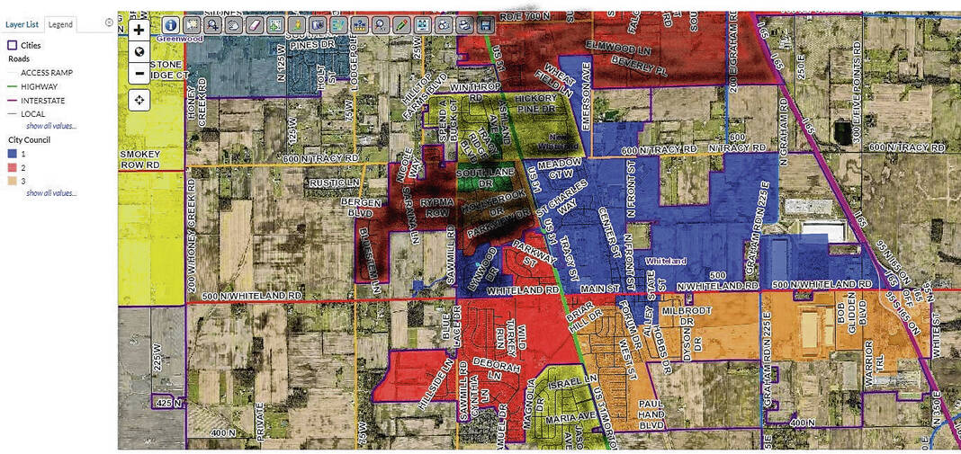
The deviation of the new proposed maps is 6%, according to town documents. Populations on the proposed new map are 1,456 in Ward 1, 1,476 in Ward 2 and 1,391 in Ward 3.
The Whiteland Town Council is set to give a final vote on the new map at their next meeting on Oct. 11.
In August, Brad Goedeker, council president, asked if the town council could eliminate its districts and just have all five members serve as at-large to represent the whole town. Goedeker said he thought that might be an idea to look into because the town council typically votes on decisions for the whole town, not just the particular districts three of them represent.
“I certainly represent Ward 2, however, there’s no decision-making that I foresee would make me want to represent Ward 2 differently than the town’s general population,” Goedeker said in August.
Watson, however, said the wards should remain in place. He cited Indiana state statute that only permits municipalities to abolish election districts if the population is below 3,500. Whiteland’s population was recorded at nearly 4,600 in 2020.

