


Franklin residents speak with Trent Newport of Crossroads Engineers during the August public hearing on the U.S. 31 project at the Franklin Community Middle School Auditorium.
Daily Journal file photo
The controversial U.S. 31 project is being updated in response to feedback from Franklin residents, education officials and business leaders.
The Indiana Department of Transportation, or INDOT, project will mostly remove the ability to cut directly across U.S. 31, which state officials say has been the source of many accidents within the corridor. Instead, the project would construct a long series of reduced conflict intersections on the five-mile stretch between South Main Street and the area just north of Israel Lane.
Dozens of people attended a public hearing on the project in early August at Franklin Community Middle School. Many of those who came were left with more questions than answers because of the format of the hearing.
Trent Newport, of CrossRoad Engineers, an engineering firm working with INDOT on the project, came before the Franklin City Council Monday to give a new presentation about the project.
He said questions weren’t answered during the public hearing because INDOT was following a federally mandated format for the public hearing. That format does not allow feedback to the public during the hearing. Though it is frustrating to the public, state officials must use this public hearing format when federal money is being used for a project, Newport explained.
People who stayed after the hearing did get their questions answered, he said.
All answers to the public’s questions will eventually be posted online when the final draft of the environmental document is completed, said Victoria Veach, of SJCA, Inc., an engineering firm working with INDOT on the project. There is no specific timeline for the responses to be posted, but the document is in review, she said.
About the project
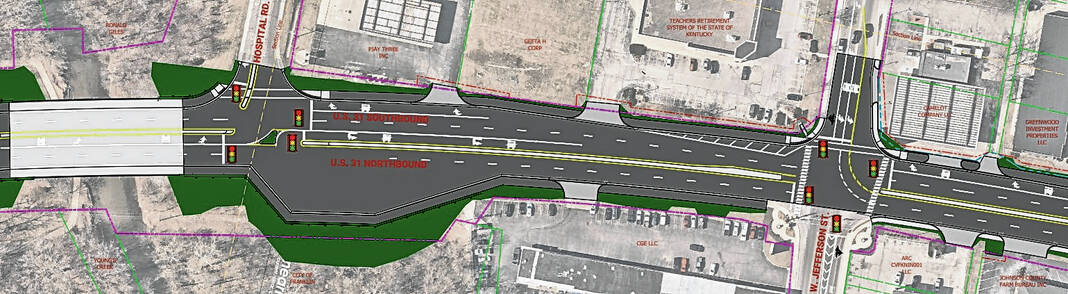
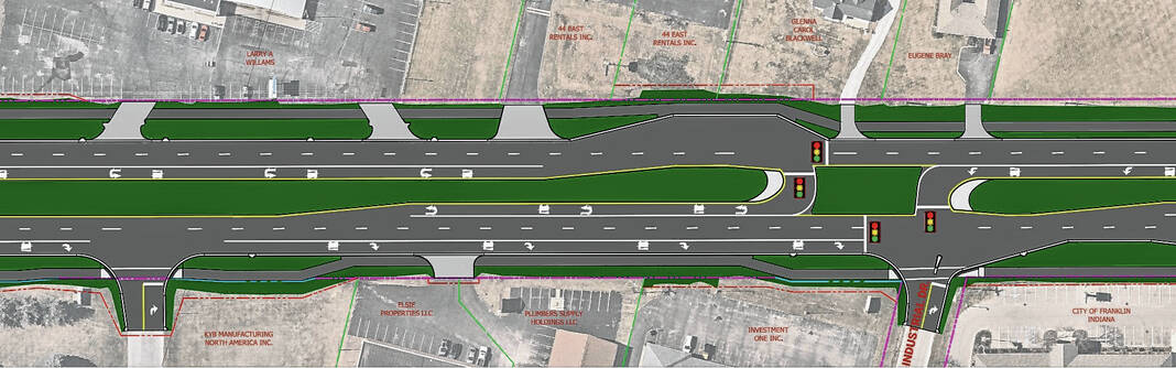
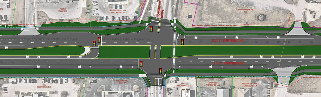
Jefferson Street and Commerce Drive are the only streets that will have cross traffic flowing between all lanes of U.S. 31, due to the volume of traffic those streets have, INDOT officials said during the August presentation.
Four types of intersections new to Franklin will be installed to reduce “conflict points” or ways that motorists can get into an accident, INDOT officials explained.
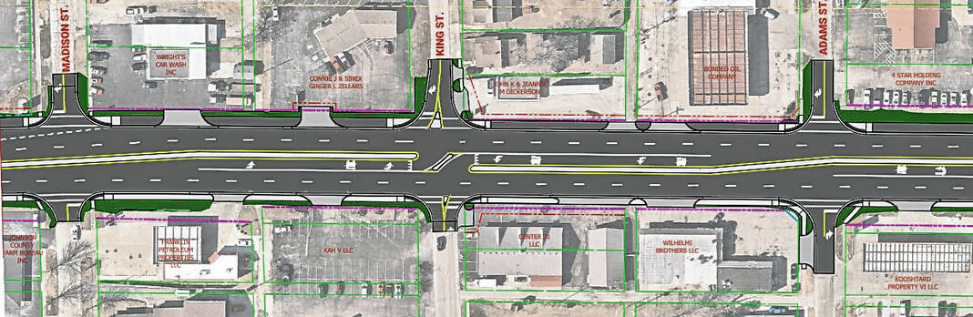
Jefferson Street will be a Partial Boulevard Left intersection, which means westbound traffic will be able to go straight or turn right, but not left, while eastbound traffic can travel in all directions. Traffic from Jefferson Street that would normally turn left would instead make a U-turn at a signalized crossing near King Street.
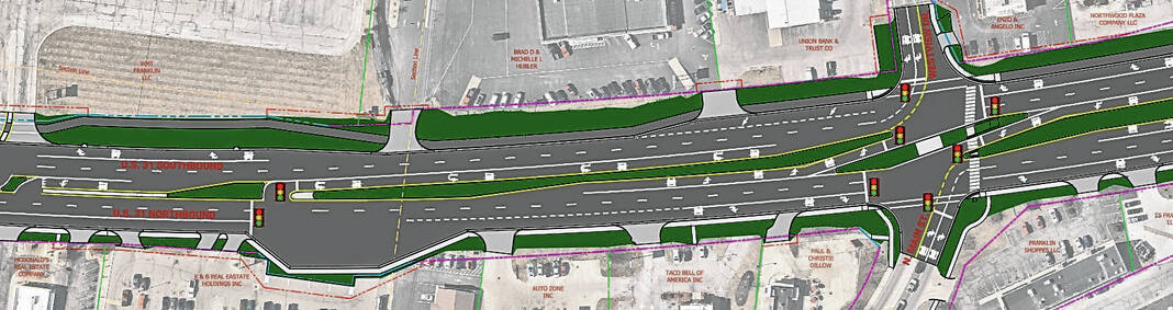
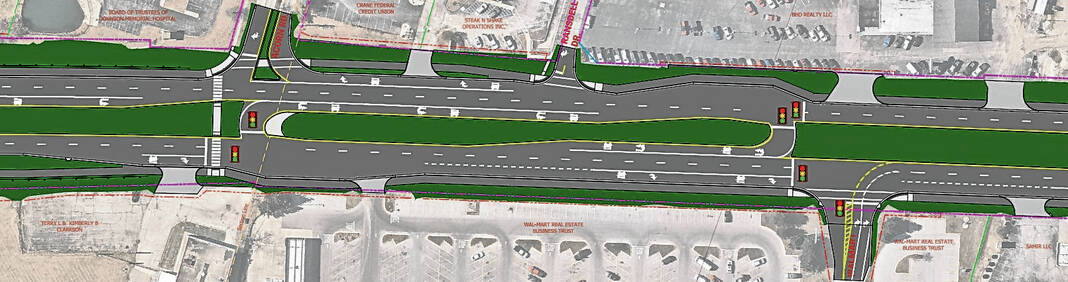
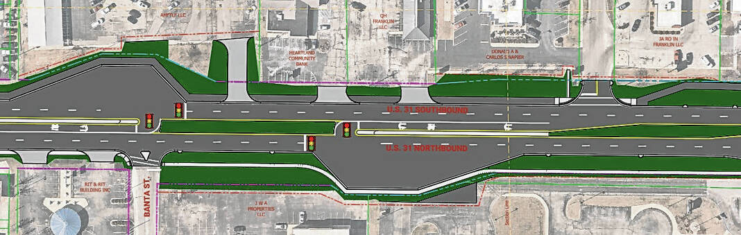
A Continuous Green-T intersection is planned at South Main Street, which means traffic from South Main Street and northbound U.S. 31 would be controlled by a signal, while southbound traffic flows freely, INDOT officials say.
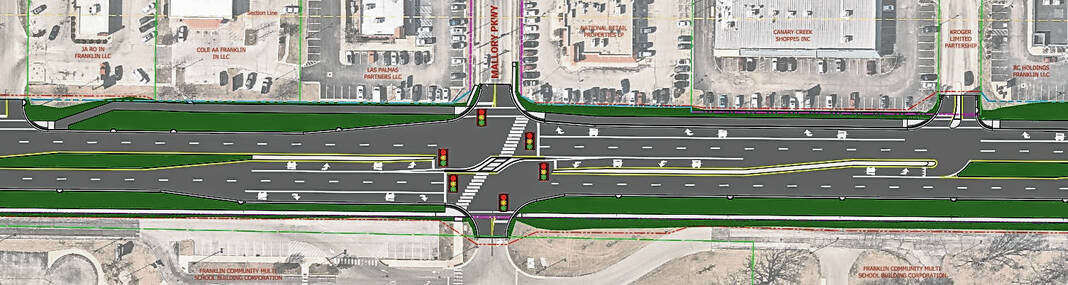
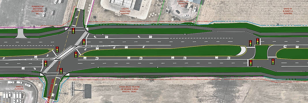
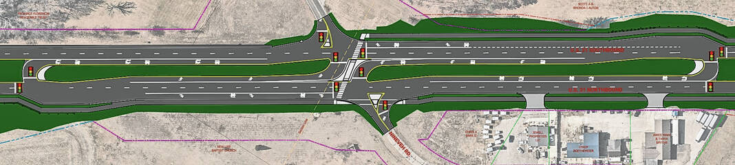
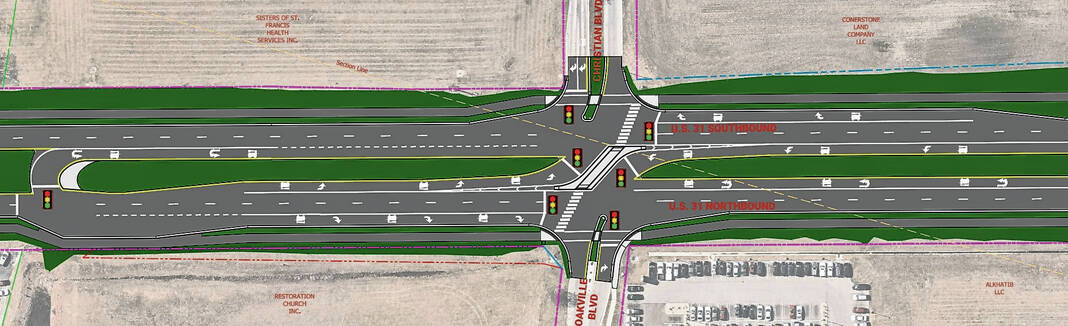
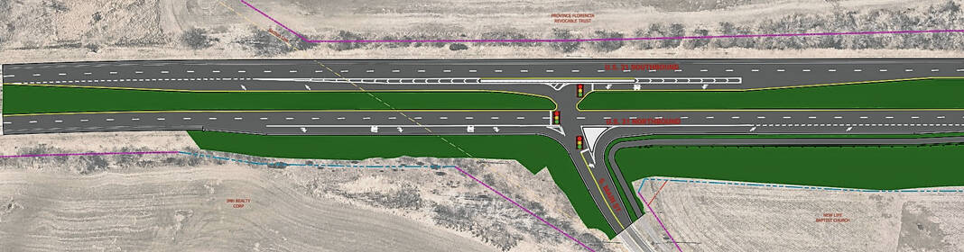
Restricted crossing U-turn, or R-CUT, intersections will be built at Nineveh Road, Franklin Lakes Boulevard and South Street, King Street, Mallory Parkway, Westview Drive/North Main Street, Earlywood Drive and Christian Boulevard/Oakville Boulevard. An R-CUT intersection is designed for all side street movements to begin with a right turn, with side street left-turn and through traffic turning right to make a U-turn at a dedicated downstream median opening.
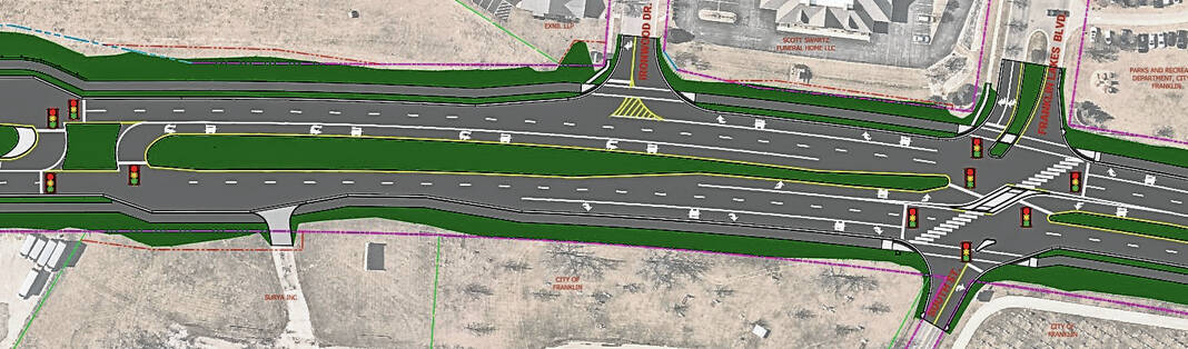
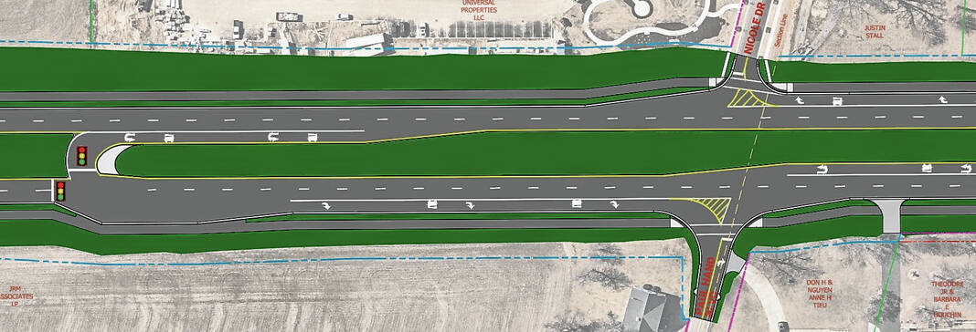
Median U-turn intersections will be installed at the remaining intersection along the corridor including Adams Street, Ironwood Drive, Hospital Road, Madison Street, Banta Street, Schoolhouse Road, Cedar Lane, Acorn Boulevard, Industrial Drive, Branigin Road, International Drive, Lancer Drive/Sloan Drive, Covington Drive, Paul Hand Boulevard/Nicole Drive and Israel Lane. MUT is a type of intersection where left-turn vehicles from one or both roads make U-turns at dedicated median openings to complete the desired movement.
MUT intersections are also being installed at the entrances to Walmart and KYB Americas Corporation to ease the flow of traffic from those highly-trafficked businesses.
Commerce Drive will be a modified MUT, as the intersection design will allow through traffic and right turns, but left-turning traffic will have to make a U-turn in a signalized lane a short distance north or south of the intersection.
About 70% of the intersections will have a traffic signal to control movement from the U-turn lane, with non-signalized intersections being in the more rural areas, Newport said Monday.
Some signals that control all lanes of traffic will remain on U.S. 31 but will be reduced in favor of controlling the flow of traffic on one side of the road or controlling flow from the U-tun lane. The signals are being changed to optimize traffic flow, INDOT officials said.
A replacement of the box culvert at Canary Ditch is also planned, and both bridges on the road will be widened to accommodate a multi-use path. The path will be either a six-foot concrete sidewalk or a 10-foot asphalt trail for the length of the project, INDOT officials say.
Sidewalks over the two bridges along U.S. 31 will be raised above the roadbed, similar to the bridge over Youngs Creek on Main Street, Newport said Monday.
The path will be constructed on both sides of the highway and will be accompanied by crosswalks, ADA-compliant curb ramps, and lighting all along the path. Landscaping will be incorporated in select areas, INDOT officials say.
What’s changed since the hearing
Since the hearing, the project timeline has been pushed back. Instead of requesting bids in spring 2023 for a fall start time, bids will be requested in fall 2023 for a spring 2024 start time, Newport said. The first part of the project to be completed will be drainage work at Canary Ditch, then construction will move to the south end of the project and move north in six phases with completion in late 2026 or early 2027, he said.
Officials have also been working through the questions and have been able to change some aspects of the project that would have posed a logistical challenge to property owners, Newport said.
Some of the main concerns raised during the hearing centered on access to some of the most traffic-intensive places along the road, including the middle school, Northwood Elementary and Turning Point Church.
A traffic study has been done in the area near the middle school and Northwood, and the results indicated that engineers should lengthen the turning lanes to accommodate the traffic volume. The lanes have been lengthened in response, Newport said.
A signal was added to the U-turn intersection at Turning Point Church, to help the flow of traffic in and out of the church, Newport said. Signals were also added at the northbound U-turn at Sloan Drive, and the north- and southbound U-turn lanes at both Covington Way and Paul Hand Boulevard/Nicole Drive, said Natalie Garrett, an INDOT spokesperson.
Several modifications have been made to allow easier movements into and out of Franklin Skate Club and Beck Automotive, Garrett said. The changes were made because engineers agreed those businesses would be challenged by the road modifications, Newport said.
A second right turn lane will also be striped at Franklin Lakes Boulevard as well as a crosswalk at Acorn Drive, Garrett said.
“We made some changes through that process and that’s what it is designed for,” Newport said. “We are continuing to take comments and address those.”
New maps of the project are not posted online as of press time, but they are expected to be added to the project page early next week. The maps were provided to the Daily Journal to accurately show the changes made since the hearing.
Newport said he has given several presentations like this one to groups in Franklin. He plans to be at the Franklin Community Schools Board of Trustees meeting on Monday to address the project.
The rationale
The purpose of the project is to reduce congestion, improve traffic flow, improve pedestrian connectivity and increase safety along U.S. 31 in Franklin, INDOT officials said in August.
INDOT officials say while these types of intersections are still relatively new in Indiana, they are proven to reduce accidents, particularly fatal accidents. These types of intersections have been built on U.S. 30 in Allen and Whitley counties, on U.S. 231 in Spencer County and U.S. 41 in Newton County.
Since construction, fatal and injury crashes in those areas have been reduced by an average of 81%, property-damage crashes are down by an average of 58% and all crashes have decreased by an average of 68%, according to data from INDOT. Nationally, statistics show crashes reduce by at least 50% where reduced conflict intersections are installed and fatal crashes decline by as much as 85%.
An INDOT review of crash history revealed a total of 697 crashes between 2014 and 2016, with 156 of those being personal injury crashes. There were 379 rear-end crashes, 100 right-angle collisions and 75 left-turn accidents.
INDOT arrived at this intersection design through detailed analysis, reviewing data and computer modeling. It was determined through that process that by eliminating left turns and through movements at most intersections, crashes would be likely to reduce in number and decrease in severity in Franklin.


