

Tornadoes and strong winds carved areas of destruction throughout Johnson County late Friday night.
Severe storms passed through Johnson County between 11-11:45 p.m Friday night, bringing heavy rain, high winds and tornadoes. The National Weather Service believes two tornadoes struck Johnson County: an EF-0 with peak winds up to 85 mph and an EF-2 with peak winds up to 135 mph.
The EF-0 tornado occurred first, touching down south of Bargersville around 11:27 p.m. and traveling northeast for about 1.9 miles, according to reports from the NWS. The EF-2 touched down approximately six minutes later on Whiteland’s far southwest side, traveling northeast for about 3.5 miles before dissipating just east of Interstate 65 near North County Road 300 East.
The damage report was not yet final as of Saturday afternoon, and the tornado could turn out to be even stronger in some pockets within Whiteland, the NWS says.
The path of destruction in Johnson County began after the storm crossed the Johnson-Morgan County line. Entering western Johnson County, the storm passed over State Road 135 and continued south of Bargersville, where it traversed farmlands and knocked down a cell phone tower, said Eric Funkhouser, Whiteland fire chief.
It then continued on through Whiteland. Winds destroyed at least 10 to 20 homes there, putting about 20 people in a temporary Red Cross shelter in the immediate aftermath of the storm. As it approached Interstate 65, it caused significant damage to warehouses on the town’s east side.
Elsewhere in the county, strong winds knocked out power, uprooted trees and damaged homes and businesses. Damage reports and outages were reported from around Morgantown, Trafalgar, Bargersville and Franklin as the storm made its way through the county.
The storm that affected the county was part of a large storm system that spawned numerous tornadoes and caused widespread destruction across the Midwest and South, including Arkansas, Iowa and Illinois Friday. At least 26 people have been reported dead from the outbreak so far, according to the Associated Press.
Tornado warnings for the Johnson County storm were first issued when it was in Illinois. As it made its way through Indiana, it spawned what is preliminarily rated an EF-3 tornado in Sullivan County, causing significant damage and killing three. In Owen County, another two people were killed at McCormick’s Creek State Park campground.
No fatalities or injuries have been reported in Johnson County.
Indiana Gov. Eric Holcomb signed state of disaster emergency declarations for both Sullivan and Johnson counties on Saturday. The Johnson County Board of Commissioners signed a disaster declaration on Sunday.


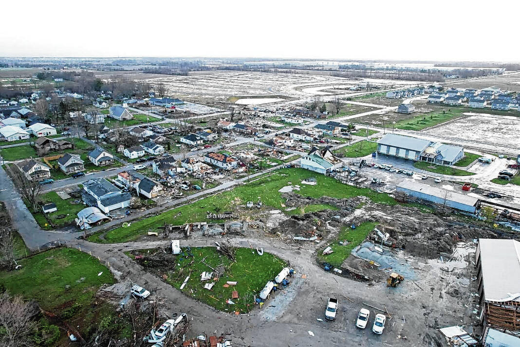


Whiteland
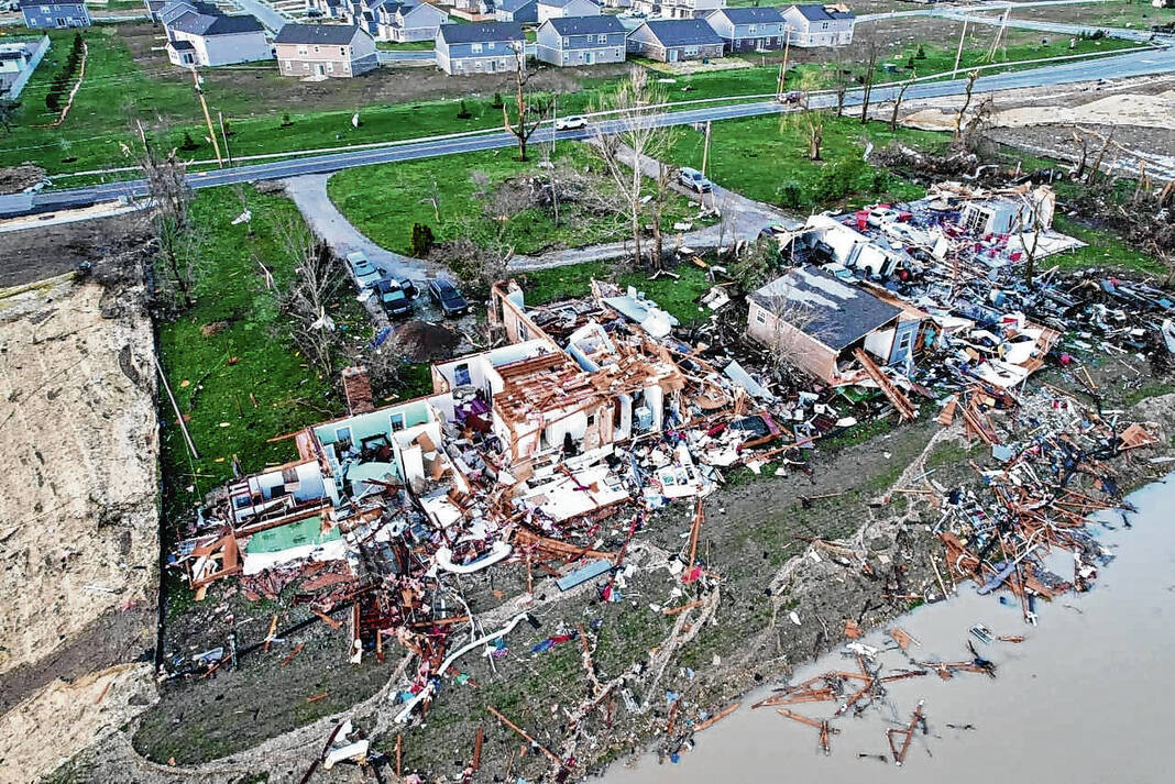
Wide swaths of Whiteland were left damaged as the tornado passed through the town of more than 4,600.
Power lines were knocked down, trees were uprooted, cars were damaged and roads were impassible. Some neighborhoods were completely inaccessible in the immediate aftermath, and some homes had sections falling apart.
The hardest hit areas of the town were east of the railroad tracks at State Street, Elm Street and Pearl Street, as well as some of West Street just west of the railroad tracks. The Park Forest area west of U.S. 31 also saw significant damage, Funkhouser said.
First responders went door to door to help those who were trapped and make sure everyone was accounted for, taking several pass-throughs and getting assistance from K-9s. Cleanup crews and firefighters worked through the day on Saturday to clean up debris on the street.
Following surveys on Saturday, the NWS said damage in Park Forest ranged from EF-0 to EF-2 strength as the twister intensified. Around this time, it also knocked down a cell phone tower near the Whiteland sewer department as it continued northeast.
After it crossed U.S. 31, the twister moved through the Spring Hill neighborhood where multiple homes had major roof damage. A few homes had most of their exterior walls collapse and a poorly-constructed home had only one wall left standing, the NWS says.
High-end EF-2 damage occurred near the railroad tracks and the area of Paris Lane and East Pearl Street. Numerous homes sustained roof damage, and a poorly-constructed and poorly-anchored home on Pearl Street was completely destroyed — leaving only a concrete slab.
The tornado continued northeast, damaging a home on Whiteland Road. Along Whiteland Road, the sleeping quarters of the Whiteland’s fire station was destroyed, Just Lift It Off Road and Fabrication and three warehouses were among the businesses with the heaviest damage, officials said.
It then hit a few more homes near Graham Road, uprooting and snapping trees, causing significant roof damage and collapsing a garage, the NWS says. A warehouse further northeast on Graham Road received preliminary high-end EF-2 damage, with portions of the warehouse being completely destroyed and blown onto I-65.
The Clark-Pleasant branch of Johnson County Public Library, located just south of the tornado’s path, sustained heavy damage to both the building’s exterior and interior areas. There is no estimate for when the building may reopen, said Jody Veldkamp, a library spokesperson.
Funkhouser was thankful there weren’t any injuries reported as the storm ripped through the town last night. He was also shocked by the amount of damage.
“I’ve been in Johnson County for … almost 24 years working in emergency services. I haven’t seen this extent of damage,” Funkhouser said. “I talked to the (Johnson County) Emergency Management Director (Stephanie Sichting) and neither of us have seen this level of destruction since we’ve been doing it.”
Funkhouser said many of the damaged homes are likely total losses.
“We’re talking roofs torn off, houses completely blown apart and completely destroyed,” Funkhouser said. “These houses are unlivable and I doubt they will ever be fixable. The majority will have to be completely torn down.”
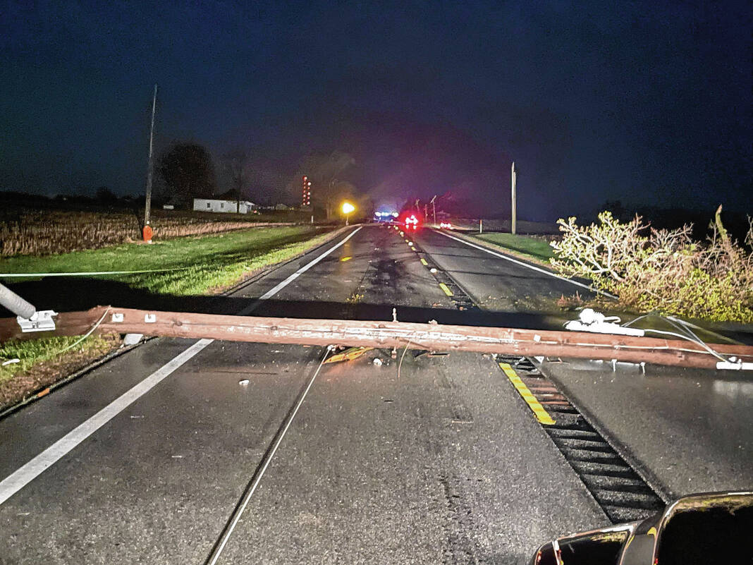
Throughout most of the day Saturday, almost the entirety of Whiteland and most of New Whiteland was without power following the storm and Johnson County REMC told Funkhouser at least 47 power poles have been damaged or destroyed, he said.
U.S. 31 was blocked from New Whiteland to the Whiteland-Franklin border due to downed power lines for most of the day Saturday.
Bargersville
Damage was reported through Bargersville and rural Union Township as the storm came through.
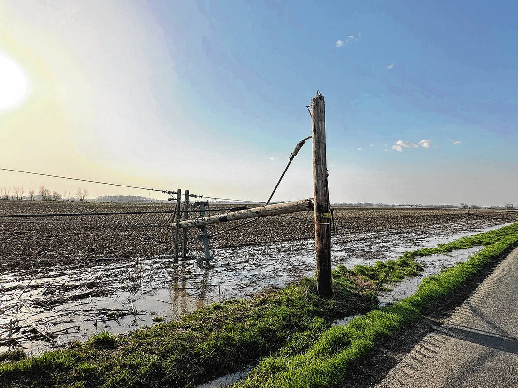
As the storm passed south of Bargersville, sporadic tree damage caused by straight-line winds was found in the Providence area. Once the EF-0 tornado was on the ground, storm surveyors found more intense tree damage, and the twister downed and damaged multiple power lines along State Road 135. It also ripped the roof off of a barn, according to the NWS.
Several roads were also blocked by debris, but by Saturday afternoon roadways were pretty much clear throughout the town, except for State Road 135 between Bargersville and County Road 100 North, said Mike Pruitt, Bargersville Fire Deputy Chief. Crews were still working to clear the road Sunday.
The biggest issue for the town by mid-afternoon Saturday was a lack of power. Work crews estimated it may take more than 24 hours for power to be restored in Bargersville, town officials said Saturday.
By 5 p.m. Saturday though, the Bargersville town utility had restored power in town, but some areas of Franklin and Whiteland still didn’t have power by Sunday afternoon, officials said in a Facebook post.
Firefighters worked with town officials on contingency plans for issues that may come up, including shelters and health care. This may not be an issue for everyone, but could be for groups including seniors, Pruitt said Saturday.
Town officials opened the town hall for a portion of the day for those who needed access to restrooms and electricity. Food was provided by the Grove Cafe for those staying at the town hall.
Franklin
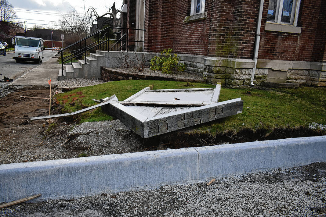
In Franklin, the Johnson County Courthouse was damaged by high winds. The winds blew out windows on the south and west sides of the courthouse’s tower.
On the south side of the courthouse, the damage was more significant. Parts of the framework surrounding the window on the tower fell away, crashing on East Court Street and some of the vehicles parked there.
Several car accidents were also reported in the immediate aftermath of the storm, said Kirby Cochran, Franklin police chief.
Power was out throughout downtown Franklin, areas of the city’s east side and south side on Saturday and Sunday. Traffic lights were out downtown, making many intersections on Jefferson Street four-way stops.
No notable injuries were been reported within the city. There was a woman who was stuck in her car near East King Street and Yandes Street after a tree and power lines fell on top of it, but she was rescued with only cuts from shattered glass, Cochran said.
Throughout the weekend, residents and officials worked to clean up the storm’s damage. Many small, garage-type structures have been hit by fallen trees, and many people pitched in to help clean up the damage, he said.
Cochran commended the way everyone worked together in the storm’s aftermath.
“Everybody, the first responders and public safety in general did a good job working together in utter chaos,” he said.
— Daily Journal reporters Emily Ketterer and Andy Bell-Baltaci and editor Leeann Doerflein contributed to this report.
DAMAGE ASSESSMENT HELP
Hoosiers impacted by the severe storms on Friday are asked to contact Indiana 211 to report damages and help with a damage assessment.
To help establish a comprehensive assessment of damages, residents can call 211 or visit the Indiana 211 website.
Agricultural damage should be reported to the Purdue Extension. The Johnson County Extension can be reached at 317-736-3724.

