


This newspaper clipping from the May 9, 1953, edition of the Franklin Evening Star details the resurgence of Urmeyville, which was considered a ghost town at one point. The photo shows the southeastern corner of the Urmeyville plat.
Franklin Evening Star Archives
For 200 years, people far and wide have come to Johnson County to call it home.
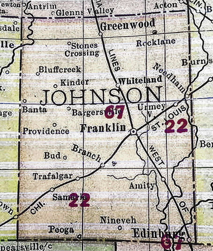
Today, thousands call the cities of Franklin and Greenwood home, along with the towns of Bargersville, Whiteland and Edinburgh, and the unincorporated area of Center Grove. Hundreds call the towns of New Whiteland, Prince’s Lakes and Trafalgar home. Many also live in unincorporated communities like Amity, Banta, Bud, Hopewell, Needham, Nineveh, Providence, Rocklane and Samaria.
Not every community in the county’s history was as prosperous as these though.
Anita, Far West, Flemingsburg, Plattsburgh, Lancaster and Mauksport are a few of the many extinct villages or ghost towns in Johnson County. Some named places would become part of present-day towns, like Pushville and Worthsville.
One would become a ghost town only to become a populated area again: Urmeyville.
Some of these places are memorialized today on maps, others have been long left off them. Many still have residents but are part of unincorporated Johnson County, while some are part of other established cities and towns.
Here’s a look at a few of those places.
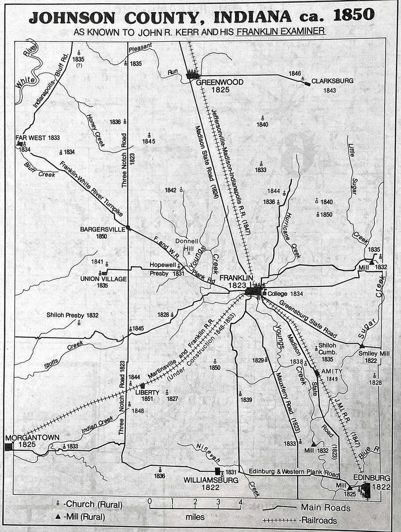
Farwest
The village of Farwest was described as the “nucleus” of very early settlement in White River Township.
Located near the Johnson-Morgan County line, the village once stood near State Road 144 and State Road 37. Most of the community was located in Johnson County, though parts stretched into Morgan County.
Before Farwest was established, the area almost became the site of Indiana’s second state capital. In 1820, the area — then called “The Bluffs” — was on the shortlist but fell one to two votes short, according to historical accounts.
In November 1833, Farwest was platted by William H. H. Pinney, consisting of 58 lots and three streets. It was thriving in its heyday and even had a church and school.
Historical accounts say Farwest’s demise was attributed to the establishment of Waverly, located about a mile south in Morgan County. The Farwest Post Office, which was established in 1835, was moved to Waverly in 1855.
The village continued to be listed on maps until the late 1880s, though it was long abandoned by then.
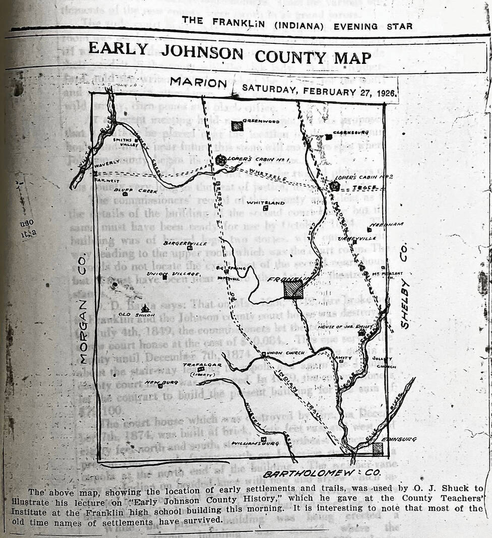
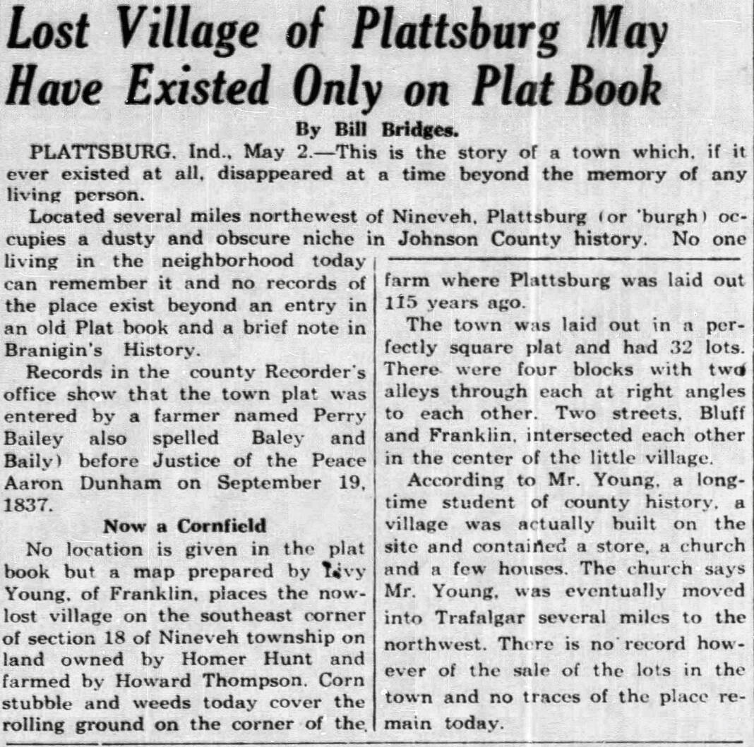
Plattsburg
The lost village of Plattsburg is one whose existence was never 100% confirmed.
Believed to be located southwest of Trafalgar somewhere in Nineveh Township, historical accounts indicate Plattsburgh may have only existed on a plat book. Bill Bridges, a reporter for the Franklin Evening Star, wrote on May 2, 1953, that “no one living in the neighborhood” could remember it and no records existed beyond an old plat book and an account in a history of the county compiled by Elba L. Branigin.
It was reported that the town plat was entered by a farmer named Perry Bailey — though the spelling could have also been Baley or Baily — in September 1837. It was laid out as a square with 32 lots, and two streets — Bluff and Franklin — intersected each other.
The article also states that “a student of county history” had said there was a village built on the site, including a church. However, the church eventually moved to Trafalgar.
Additionally, there were records of lots being sold, according to the article.
Worthsville and Pushville
Before the names were assigned to roads on Greenwood’s south side, Worthsville and Pushville were a pair of tiny settlements that popped up in the mid-1800s.
Worthsville was located at the railroad crossing with the Pennsylvania track, now the Louisville and Indiana track. Charles Henry, a long-time resident of the Worthsville area, told the Evening Star on June 23, 1953, that he remembered a time when there was a railroad switch at the crossing, along with one house on the corner.
For a time, the owners of the house ran a store out of the home. Eventually, it was sold to Jim Coons, a day laborer who tragically died when he was hit by a train going south to Whiteland on his way home in 1883. After this, the home was occupied by several day laborers before it was torn down.
Worthsville also had a post office from 1850 to 1866, historical records show.
Pushville was more prosperous than Worthsville, boasting at one time a sawmill, blacksmith, several homes and a schoolhouse, according to the article.
The schoolhouse, known officially as District School No. 12, was originally a white frame building. It was torn down and a brick building was put in its place.
The name Pushville was coined by a man named Dick Glass, who assisted a blacksmith. Someone had asked for the place to be named, and he suggested Pushville, according to a letter from Elmer E. Henderson published in the Evening Star on June 26, 1953.
Turpey/Pea Ridge
This lost community was located in Union Township, west of the area known as Providence.
Named for an Indiana senator, an Irishman named Sam Montgomery was its “leading citizen and its chief reason for being,” according to a July 13, 1953 article in the Evening Star. When Montgomery and his wife moved to the county around 1870, he built a store and sawmill.
After Montgomery moved in, other settlers followed. Eventually, there were six or seven houses in the neighborhood, along with a gunsmith and a blacksmith, the article says.
For several years in the late 1880s and early 1890s, Turpey was the site of one of Union Township’s four post offices. In 1899, postal service was dropped, according to the article.
When the name of the village was also dropped, the area became known as Pea Ridge. The Evening Star even had a Pea Ridge correspondent.
Turpey was also sometimes spelled Turpie, though most accounts spell it with the “y.”
Cottletown
Cottletown, located south of Trafalgar along the Indian Creek, was best known for its sawmill.
Sometimes called Cottleville, the name was given to a sawmill owned by James M. Cottle. It was one of the landmarks for the southwestern part of the county during the mid-1800s, according to a Sept. 4, 1953, article in the Evening Star.
But whether it was more than just a mill is uncertain, although at least two local historians in 1953 believed there were at least a few houses.
“In the sparsely settled country of the early 1800s, half a dozen dwellings constituted a sizable community and two houses side-by-side were often given a name,” the article says.
The mill was abandoned around 1860, but the name lingered for several years.
Bluff Creek/Browntown
Browntown was a small country village in White River Township, located at the intersection of State Road 144 and Smokey Row Road. It was established in 1855.
The town was not regularly platted, with records indicating it was merely the outgrowth of a “neighborhood’s demand for a trading post and a post office.” The post office, named Bluff Creek, was in operation from 1856 to 1904.
Bluff Creek Christian Church was established on the northwest side of the town in 1884. The church stands on the same site today.
Kinder
Kinder was a village established sometime in the 1860s. It was located southwest of Browntown in White River Township, near the intersection of State Road 144 and Morgantown Road
A post office was established in 1886 but later closed in 1902.
Today, the area is part of Bargersville.
Anita
Anita was an 1800s railroad town located in southwestern Johnson County.
Located west of Trafalgar, the now-defunct Indianapolis Southern Railway built a station there in 1906. Ray S. Blinn, a civil engineer who had helped find the location, proposed naming the station Anita after his infant daughter, Anita Blinn, TheStatehouseFile.com reported.
A town soon rose around the station, and the area became a hub for business. People would go to the station to take a trip to Indianapolis, according to the article.
In 1911, the station changed ownership, being bought out by the Illinois Central Railroad. Eventually, it was turned into a flag stop, and by 1936 all operations were ordered to cease, the article says.
By the 1960s, evidence of the village was gone. In the 1980s, it was nearly removed from maps, an effort stopped by local residents who wanted to preserve its memory. A resolution introduced by State Rep. Woody Burton would lead to it being kept on the maps, according to newspaper reports in the Daily Journal.
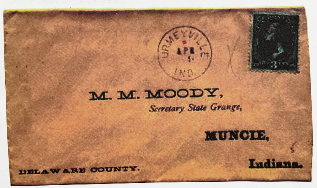
Urmeyville
Urmeyville was once considered a ghost town, though by the 1950s it was no longer.
Located about a mile south of Needham, Urmeyville was platted in 1865 by Henry Fisher, who also ran the post office and a store. In its early days, it boasted a post office, a grain storage warehouse, a blacksmith and a manufacturing company, according to a May 9, 1953, article in the Evening Star.
It was laid out with 39 lots and three streets, on both sides of the railroad. Eventually, the post office was closed, transferring mail to nearby Needham, but Fisher’s store continued to operate for several years — even after his death.
By the 1930s, many of the businesses had closed or disappeared. It was believed the continued growth of Needham was a factor in the decline, according to the article.
But by the 1950s, more homes were being built and people were moving into the area. It is still inhabited today, but like Needham, it is part of unincorporated Johnson County. It does not always appear on maps


