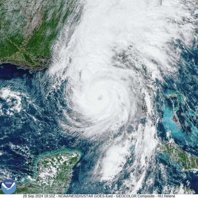
Johnson County is hundreds of miles from the Gulf Coast of Florida, but Hurricane Helene will still bring major weather impacts to the county this weekend.
Fast-moving Hurricane Helene was advancing Thursday across the Gulf of Mexico toward Florida, threatening a “catastrophic” storm surge in northwestern parts of the state as well as tornadoes, damaging winds, rains and flash floods hundreds of miles inland. It was upgraded to a Category 4 storm Thursday evening, having sustained winds of at least 130 mph, according to the National Hurricane Center. The huge storm’s center is expected to make landfall in the Big Bend area of Florida’s northwestern coast Thursday evening.
But the storm’s impacts will stretch far beyond Florida as it moves inland, with the storm expected to impact much of the southeastern U.S. before continuing northwest and bringing rainfall as far away as Tennessee, Kentucky and Indiana.
For Central Indiana and Johnson County, expected impacts — rain and high winds — will arrive on Friday. The heaviest rainfall, of at least more than one inch, will likely be south of the Interstate 70 corridor, with rain lingering through the weekend, the National Weather Service in Indianapolis said.
In Franklin, rainfall chances go from 61% at 6 a.m. to 84% by noon.
Winds will gust to 40 to 45 mph with “locally higher gusts,” possible on Friday, forecasters say. The strongest winds are expected in the 3 to 8 p.m. time frame where sporadic gusts above 55 mph could occur.
In Franklin, winds are expected to start picking up by 9 a.m. Friday, with gusts going over 40 mph by noon, according to forecasts.
Ahead of the impacts’ arrival Friday, a wind advisory was issued for Johnson County and other areas of central Indiana. It is in effect from 10 a.m. to 9 p.m. Friday.
Gusty winds could result in power outages and potentially areas of tree and structural damage across the area. They could also blow around unsecured objects, the weather service says.
The remnants from Helene will become the second from a hurricane to impact Central Indiana this year. Remnants from Hurricane Beryl in July brought more than an inch of rainfall, the weather service says.
Meanwhile, Indiana Task Force 1 safely arrived in Florida Wednesday ahead of the storm. Eighty members of the urban search and rescue task force deployed to Florida to assist in the response to the storm.
Four local firefighters and paramedics deployed with the task force: Lt. Joe Kipfer, a rescue specialist from the Bargersville Community Fire Department; firefighter Daniel McElyea, a rescue specialist from the Franklin Fire Department; and firefighter Michael Combs and paramedic Chelsea Spina, a communications specialist and a medical specialist, respectively, from the White River Township Fire Department.
Johnson County REMC has also sent a crew and equipment to assist in recovery efforts, along with 11 other electric cooperatives. About 40 line workers from the cooperatives left Thursday to assist Cobb EMC near Marietta, Georgia, which provides electric service to nearly 200,000 residential and commercial consumers in five Georgia counties.
“Every cooperative in the Indiana electric cooperative family is an integral part of a state and national network of hundreds of fellow cooperatives,” said John Cassady, CEO for Indiana Electric Cooperatives, in a news release. “It is incumbent upon us to work together and help one another in times of disaster, to make sure our power delivery systems are repaired as quickly, safely and cost-effectively as possible.”
The Indiana electric cooperative mutual aid program provides cooperative assistance in service restoration from storms or other events that result in significant power outages, the news release said.
Down south, Helene could cause a “nightmare” scenario of catastrophic storm surge in northwestern Florida, officials warned Thursday as they urged residents to heed evacuation orders ahead of the storm, which is expected to cause significant damage hundreds of miles inland across much of the southeastern U.S.
While Helene will likely weaken as it moves inland, damaging winds were expected to extend to the southern Appalachian Mountains, where landslides were possible, forecasters said. The center posted lesser tropical storm warnings as far north as North Carolina, and warned that much of the region could experience prolonged power outages and flooding.
Helene had swamped parts of Mexico’s Yucatan Peninsula on Wednesday, flooding streets and toppling trees as it passed offshore and brushed the resort city of Cancun.
The storm formed Tuesday in the Caribbean Sea. In western Cuba, Helene knocked out power to more than 200,000 homes and businesses as it brushed past the island.
Helene is forecast to be one of the largest storms in breadth in years to hit the region, said Colorado State University hurricane researcher Phil Klotzbach told the Associated Press. He said since 1988, only three Gulf hurricanes were bigger than Helene’s predicted size: 2017’s Irma, 2005’s Wilma and 1995’s Opal.
Helene is the eighth named storm of the Atlantic hurricane season, which began June 1. The National Oceanic and Atmospheric Administration has predicted an above-average Atlantic hurricane season this year because of record-warm ocean temperatures.
The Associated Press contributed to this report.
Editor’s note: This story was updated at 6:25 p.m. Thursday with information about Helene being a Category 4 hurricane.


