

The National Weather Service preliminarily confirmed that a tornado struck Camp Atterbury on Saturday, and officials said straight-line winds were likely responsible for damage reported in other parts of the county.
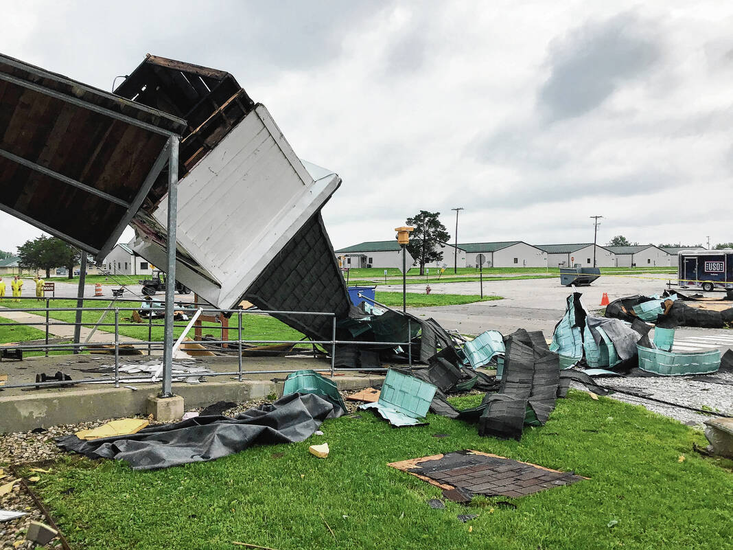
An EF-0 tornado with estimated peak winds of 84 mph briefly touched down around 3:48 p.m. Saturday at Camp Atterbury. EF-0 tornadoes have winds between 65 to 85 mph, and this twister’s path was less than a mile long, according to the NWS.
The steeple of the chapel at the base was blown over and several vehicles were lifted slightly due to the tornado. Plywood debris from the roof of the church was found underneath the tires of the cars, the agency said.
The agency also said there were widespread straight-line winds of between 80 to 90 mph that created significant uprooted and broken trees along the damage path as well.
While the chapel at the Indiana National Guard base was damaged, the rest of the base is otherwise operational, Lt. Col. Randi Bougere, communications director, said on Saturday. Staff at the base are looking for an alternative location for church services, she said.
In other areas of the county, including Edinburgh, Nineveh and Princes Lakes, damage was caused by straight-line winds. The NWS had found the only confirmed tornado touchdown in the county to be at Camp Atterbury, said Stephanie Sichting, Johnson County Emergency Management Agency director.
In Princes Lakes, several homes were damaged by trees, and both trees and powerlines were blocking four streets, Town Marshal Greg Southers said Saturday. With the whole town out of power, public safety officials brought generators to a home with people on life support to make sure their life-saving medical devices stayed on until power was restored this weekend.


In the surrounding area, firefighters responded to two collapsed homes and at least one person was entrapped, Sichting said. No deaths or significant injuries were reported as a result of the storm so far, she said.
Most power had been restored across the county by Monday, officials said. Utility crews, police officers, firefighters, county and town employees worked to clean up and restore power in affected areas over the weekend and Monday.
Edinburgh appeared to be the hardest hit area of the county. The storm seemed to be the most severe the town has seen in a while, Town Manager Dan Cartwright said Saturday.
There were still about a dozen locations without power in Edinburgh on Monday, and crews are working to get it restored as soon as possible, the town said. Most of the clean-up taking place Monday was in Edinburgh, and people in the town have come together to clean up the damage, Sichting said.
“They had neighbors helping neighbors. Everyone was out there pitching in,” she said.
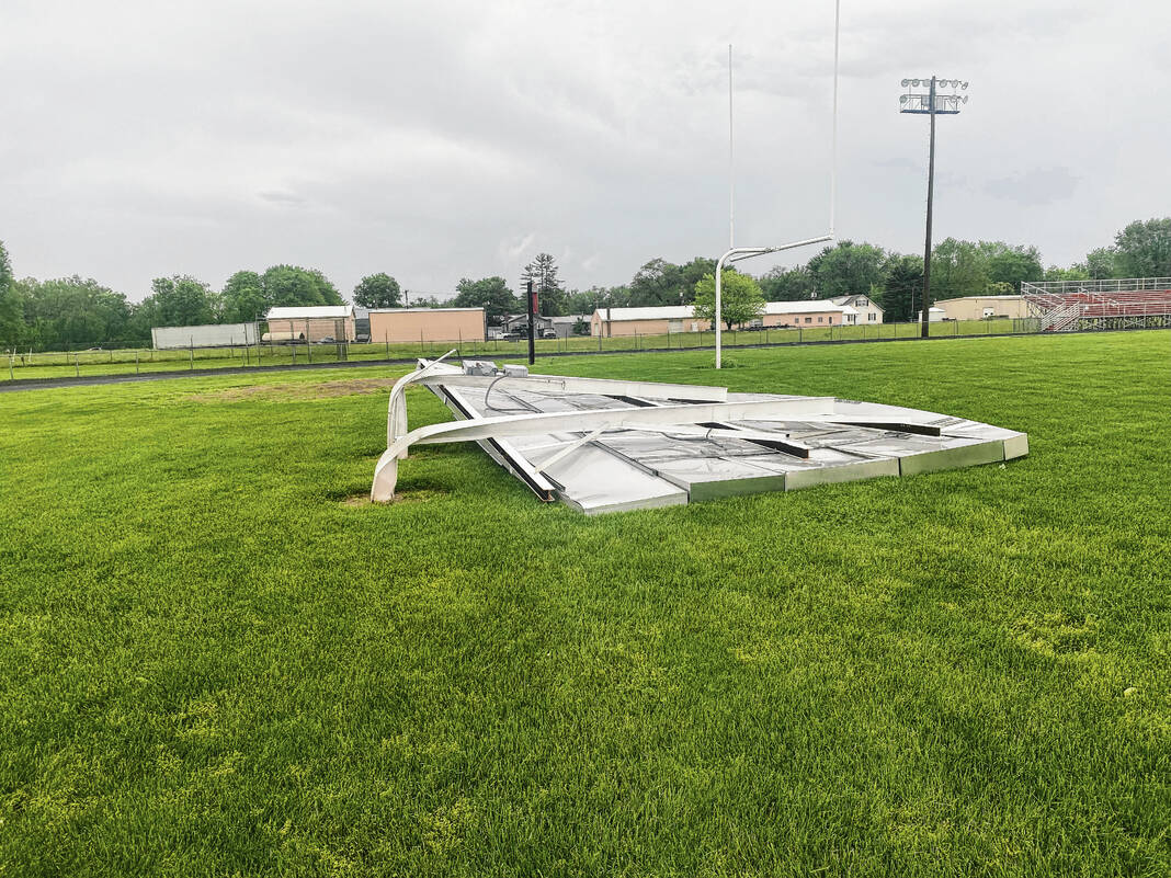
In the aftermath of the storm this weekend, many Edinburgh residents came out to survey the damage and help clean it up. Residents went to neighbors’ homes after cleaning up their own. Over by Edinburgh Community High School, student-athletes and their parents were examining the damage done to the football field. A scoreboard that was replaced earlier this year collapsed and was destroyed by the winds from the storm.
The was also significant damage in Taylorsville, just south of Edinburgh. Several homes were heavily damaged by fallen trees at a Taylorsville trailer park, making it the hardest-hit area of Bartholomew County, according to a media release from county officials.
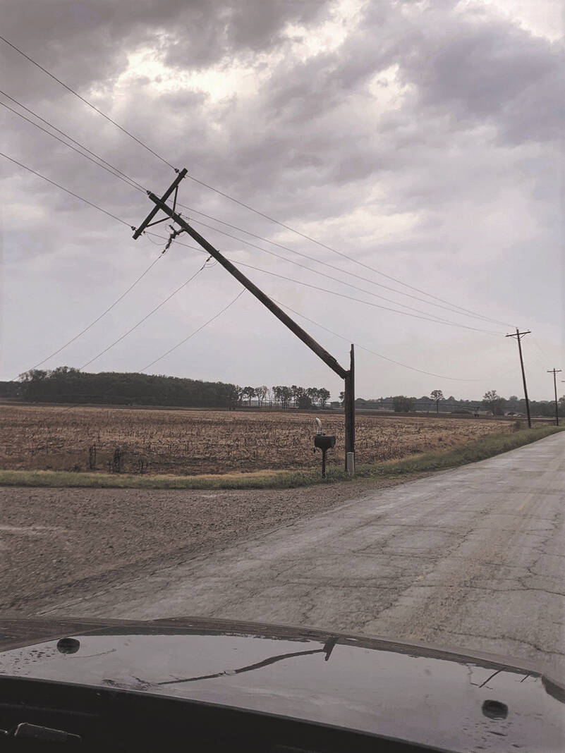
Southbound lanes of U.S. 31 were shut down in Amity and southbound lanes of Interstate 65 were shut down north of Edinburgh because of downed trees for several hours Saturday. With power out and roads impassable in some parts of town, Edinburgh officials had also blocked off State Road 252 and other streets temporarily to give clean-up crews room to do their work. Side streets and county roads were also littered with trees and downed power lines.
Saturday’s storms caught many by surprise in Johnson County. The weather popped up so fast local officials did not get a notification to activate tornado sirens, Sichting said. When the weather turned severe, there was only a thunderstorm watch for the county.
To activate the sirens, the NWS has to send out information that a tornado has been indicated by radar or spotted on the ground to the county’s 911 dispatch center. Once the dispatch center gets this information, then sirens are set off. But that information did not come on Saturday afternoon, Sichting said.
NWS did not issue a tornado warning for the storm that day until it was already out of Johnson County, in the area near Shelbyville. The storm did more significant damage in Shelby County and seemed to increase in power as it went east, damage reports from local officials indicate.
People on social media reported seeing rotation in clouds near Trafalgar, but there was less damage there than in other southern Johnson County towns, Trafalgar Police Chief Charles Roberts said Saturday.
The storm intensified quickly and cut a path of damage across southern Johnson County, from Trafalgar to Edinburgh roughly in the path of State Road 252, Sichting said. However, Nineveh and Princes Lakes also saw significant damage, she said.
While only one tornado touched down in Johnson County, two other tornadoes touched down in Brown and Shelby counties.
The first tornado, also an EF-0, touched down five miles south of Princes Lakes in Brown County around 3:40 p.m. Saturday, lasting for two minutes. The twister had estimated peak winds of 84 mph and traveled for about 0.3 miles along Mt. Moriah Road and Persimmon Ridge Road before dissipating, according to the NWS.
The third tornado, an EF-1 with estimated peak winds of 100 mph, touched down in Shelby County about three miles north-northeast of Edinburgh around 3:57 p.m., lasting for 15 minutes before dissipating four miles west-northwest of St. Paul around 4:12 p.m. EF-1 tornadoes can have winds between 86 to 110 mph, the NWS said.
The twister skipped along its entire 13.7-mile path in Shelby County. The damage path had a maximum width of 100 yards in Mt. Auburn, and along its path in the county there were many trees down or uprooted, the agency said
The NWS also said widespread straight-line winds of between 80 to 90 mph created significant uprooted and broken trees within a wide area along the damage path for both twisters.


