

An estimated $50 million project reimagining five miles of U.S. 31 in Franklin will begin next year after six years of planning.
The Indiana Department of Transportation, or INDOT, project will mostly remove the ability to cut directly across U.S. 31, which state officials say has been the source of many accidents within the corridor. Instead, the project would construct a long series of reduced conflict intersections on the five-mile stretch between South Main Street and the area just north of Israel Lane.
People online, at public meetings and in complaints to city of Franklin and state officials have questioned many aspects of the project. The Daily Journal asked experts, city officials and U.S. 31 corridor stakeholders questions about the project to get answers ahead of the start of construction in 2024.

About the project
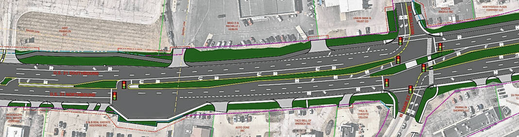
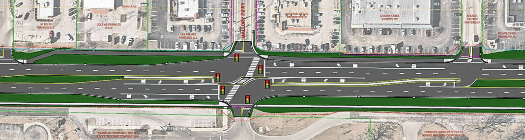
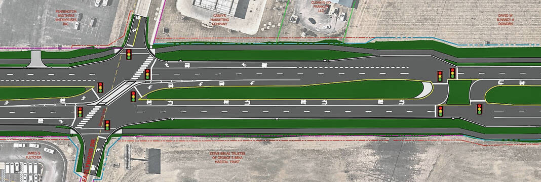
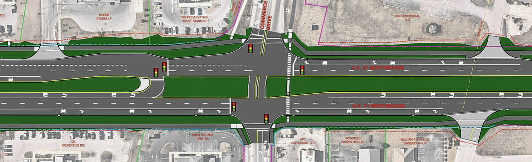
Jefferson Street and Commerce Drive are the only streets that will have cross traffic flowing between all lanes of U.S. 31, due to the volume of traffic those streets have. Four new types of intersections will be installed to reduce “conflict points” or ways that motorists can get into an accident, INDOT officials say.
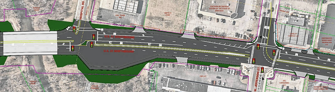
Jefferson Street will be a Partial Boulevard Left intersection, which means westbound traffic will be able to go straight or turn right, but not left, while eastbound traffic can travel in all directions. Traffic from Jefferson Street that would normally turn left would instead make a U-turn at a signalized crossing near King Street.
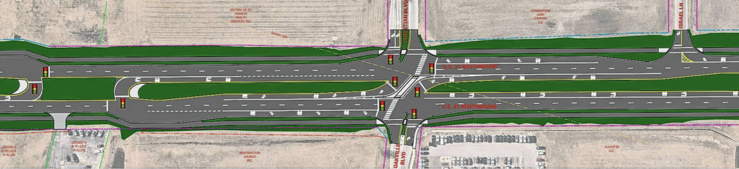
A Continuous Green-T intersection is planned at South Main Street, which means traffic from South Main Street and northbound U.S. 31 would be controlled by a signal, while southbound traffic flows freely, INDOT officials say.
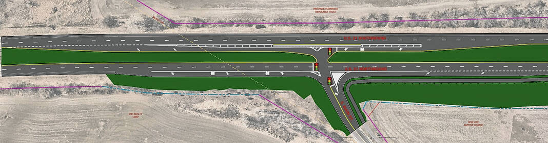
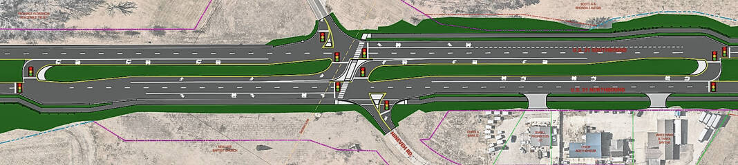
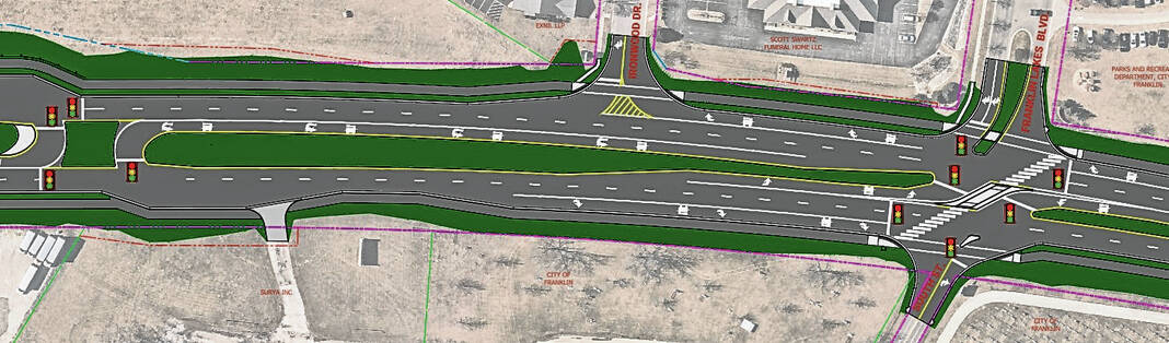
Restricted crossing U-turn, or R-CUT, intersections will be built at Nineveh Road, Franklin Lakes Boulevard and South Street, King Street, Mallory Parkway, Westview Drive/North Main Street, Earlywood Drive and Christian Boulevard/Oakville Boulevard. An R-CUT intersection is designed for all side street movements to begin with a right turn, with side street left-turn and through traffic turning right to make a U-turn at a dedicated downstream median opening.
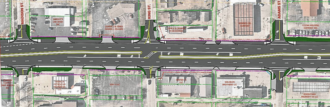
Median U-turn intersections will be installed at the remaining intersection along the corridor including Adams Street, Ironwood Drive, Hospital Road, Madison Street, Banta Street, Schoolhouse Road, Cedar Lane, Acorn Boulevard, Industrial Drive, Branigin Road, International Drive, Lancer Drive/Sloan Drive, Covington Drive, Paul Hand Boulevard/Nicole Drive and Israel Lane. MUT is a type of intersection where left-turn vehicles from one or both roads make U-turns at dedicated median openings.
MUT intersections are also being installed at the entrances to Walmart and KYB Americas Corporation to ease the flow of traffic from those highly-trafficked businesses.
Commerce Drive will be a modified MUT, as the intersection design will allow through traffic and right turns, but left-turning traffic will have to make a U-turn in a signalized lane a short distance north or south of the intersection.
About 70% of the intersections will have a traffic signal to control movement from the U-turn lane, with non-signalized intersections being in the more rural areas where traffic will be lighter, INDOT officials said.
Some signals that control all lanes of traffic will remain on U.S. 31 but will be reduced with a focus on controlling the flow of traffic from the U-tun lane and either the northbound or southbound lanes of traffic individually. The signals are being changed to optimize traffic flow, INDOT officials said.
A replacement of the box culvert at Canary Ditch is also planned, and the bridges over Canary Ditch and Youngs Creek will be widened to accommodate a multi-use path. The path will be either a six-foot concrete sidewalk or a 10-foot asphalt trail for the length of the project. Sidewalks over the two bridges along U.S. 31 will be raised above the roadbed, similar to the bridge over Youngs Creek on Main Street, INDOT officials say.
The path will be constructed on both sides of the highway and will be accompanied by crosswalks, ADA-compliant curb ramps, and lighting all along the path. Landscaping will be incorporated in select areas, INDOT officials say.
What are the goals of this redesign?
The purpose of the project is to reduce congestion, improve traffic flow, improve pedestrian connectivity and increase safety along U.S. 31 in Franklin, INDOT officials say.
INDOT arrived at this intersection design through detailed analysis, reviewing data and computer modeling. It was determined through that process that by eliminating left turns and through movements at most intersections, crashes would be likely to reduce in number and decrease in severity in Franklin, officials say.
This stretch of U.S. 31 has been called the most dangerous in Indiana, due to the high number of crashes. As a result, coming up with a solution to reduce accidents has been on the state’s radar for years, said Natalie Garrett, an INDOT spokesperson.
Other solutions, such as building roundabouts at some intersections and creating a road design similar to Keystone Parkway and U.S. 31 in Hamilton County were both ruled infeasible, project documents show.
City officials are also meeting their goal to connect the commercial corridor and neighborhoods east of U.S. 31 to downtown with this project, Mayor Steve Barnett said.
What is the timeline?
The project will start around spring 2024, with the timeline to be finalized following the award of the project bid later this year. The state is accepting bids for the project in September.
The project will begin with the replacement of the drainage structure on Canary Ditch, followed by work on the bridge over Youngs Creek. The project will then move to the south end of the project and reconstruct sections of the road across six phases in a period of two years.
City officials have been told that each section of the project after the bridge work will be broken into mile-long sections that will take about six months each to complete, said Mark Richards, Franklin city engineer.
Is this an experiment?
No. These types of intersections have been installed elsewhere in Indiana and there’s data that shows they reduce accidents.
While these types of intersections are still relatively new in Indiana, they are proven to reduce accidents, particularly fatal accidents. These types of intersections have been built on U.S. 30 in Allen and Whitley counties, on U.S. 231 in Spencer County and U.S. 41 in Newton County, INDOT officials say.
Since construction, fatal and injury crashes in those areas have been reduced by an average of 81%, property-damage crashes are down by an average of 58% and all crashes have decreased by an average of 68%, according to data from INDOT. Nationally, statistics show crashes reduce by at least 50% where reduced conflict intersections are installed and fatal crashes decline by as much as 85%.
An INDOT review of crash history revealed a total of 697 crashes between 2014 and 2016, with 156 of those being personal injury crashes. There were 379 rear-end crashes, 100 right-angle collisions and 75 left-turn accidents.
In addition, these types of intersections have yielded similar accident reduction statistics in multiple states across the country. And many of these intersections are in populated areas, Richards said.
Nationwide, statistics show a more than 50% decline in crashes where these intersections are installed. Fatal crashes decline by as much as 85%.
Didn’t the same thing fail in Fishers?
A common comparison is made between this project and a J-turn that Fishers installed on Allisonville Road in the 1990s. Some are scrutinizing this project because the Fishers government decided last year the J-turn would be dumped in favor of a roundabout.
Richards said that’s not an accurate comparison.
“The intersection was a single intersection. And if it didn’t take into account how traffic at adjoining intersections impacted the operation of that J-turn project. So I don’t think you’re comparing apples to apples if you throw that one out there,” he said.
Accidents were down, is the project still needed?
Some people have pointed out that accidents have declined from the numbers that INDOT has used to justify the project. However, INDOT officials believe the decline in accidents is temporary.
Compared to 2014 to 2016 accident data, traffic counts and crashes were 10 to 15% lower in data from 2019-2021, Garrett said part of this is because the COVID-19 pandemic decreased traffic volumes both state and nationwide. INDOT officials believe traffic volumes and crash numbers will return to pre-pandemic levels, Garrett said.
Though certain intersections, such as Simon Road, have been modified already, that doesn’t solve the whole problem, because accidents happen up and down the corridor.
“An opportunity to reduce those accidents has presented itself with this project. And from that perspective, I think it’s a great project … I think it’s a good project overall anyway,” Richards said. “But what people fail to understand is that the traffic is only going to continue to get worse. This is a solution that, according to the traffic experts, will work.”
Simon Road was closed following horrific accidents at the intersection. Just before the intersection closed there were two days in a row that cars were T-boned and thrown into the ditch. Barnett recalls that one of the accidents resulted in an elderly woman getting thrown through the glass of her windshield.
“The state along with the city decided the right thing to do was to close that before somebody got killed at that intersection,” Barnett said. “There are other intersections like that that this is going to make safer, not only for pedestrians but for the cars and people that traveled the road.”
Will businesses lose customers?
Barnett thinks it is unlikely businesses will lose customers based on what the city has seen from Simon Road’s closure. With the crossing cut off, city officials haven’t heard of any business loss from places like Lowe’s, Buffalo Wild Wings, Starbucks and Chili’s that are only accessible from one side of U.S. 31, Barnett said.
“Those businesses tell me that it does not hurt them at all,” he said. “People have to go farther north at Commerce, turn around and come back. They’re already doing that.”
Even before Simon Road closed, the grassy median has long cut-off access to businesses on one side of the street in places without a designated path across.
Barnett thinks this will actually be good for business in the long run.
“I really feel like in the end, this is going to be a very good safe project for the city of Franklin. It is going to enhance our businesses down through 31 with walkability and safer access to their businesses,” he said.
What input did people get on this project?
The project has been talked about since 2017. Readers of the Daily Journal were first made aware of preliminary plans for the project in 2018. Another story in January 2020 delved deeper into the alternatives that were under consideration.
The city of Franklin held an informal public information session on the project in February 2020 and a formal public hearing was held on the project at Franklin Community Middle School in July 2022. In between those meetings, Barnett discussed the project during his annual State of the City addresses, which were made available for the public to view online.
The public was able to provide feedback and ask questions of INDOT and Crossroads Engineers during the public hearing and in a months-long public comment period after the meeting. In addition, Trent Newport of Crossroads Engineers has made rounds in Franklin speaking about the project to community groups like the Franklin Chamber of Commerce, Franklin Rotary Club and Franklin City Council in the period since the public hearing.
The project was edited after public input and additional traffic studies to study specific parts of the corridor where stakeholders had expressed concerns about the length of a turn lane or lack of a traffic signal for the U-turn lane, Newport said in November.
A document posted online on the U.S. 31 project website details all public comments.
Can public safety vehicles be accommodated?
Franklin police and fire protection has been thought of since early on in the project. Both fire stations that are on U.S. 31 will have access to cut across, Barnett said.
“In talking to our fire chief and the fire chiefs before him are no issues with fire. We don’t see any way or any scenario to slow anybody down. And the same thing with the police; there are no issues there,” Barnett said.
The U-turn lanes are also built to be navigated by large vehicles such as fire trucks, school buses and semi-trucks.
How does this impact Franklin schools?
The project has already been adjusted to accommodate the high traffic volume at Northwood Elementary and the middle school. Adjustments were also made at the Branigin Road intersection to better accommodate busses and student drivers who use the road to get to the high school, said Jeff Sewell Franklin Schools’ director of operations.
After the public hearing, a traffic study was done and edits were made to the project based on the study’s findings, Newport told the city council in November.
After the initial adjustment period, school officials don’t expect the new intersections will cause lasting headaches. During construction, school bus routes will have to change in response to the road conditions as contractors work their way through the corridor. After construction, routes would also change to accommodate the new traffic pattern, Sewell said.
Time will tell what the overall impact is, but school officials are hoping the new intersections will help with traffic queues that busses get caught in at major crossings like Commerce Drive and Jefferson Street, he said.
What about Access Johnson County?
Leaders of the county’s public transportation agency Access Johnson County are now cautiously optimistic about the project after initial concern. Becky Allen, director of transportation, spoke at the public hearing last year and was concerned because U-turns are considered preventable accidents and their drivers are trained not to make them.
However, after seeing that many of the U-turns are signalized and that INDOT has made other adjustments to the project, Allen said she feels much better about the situation. The remaining concern is whether there will be enough time for drivers to get all the way left to the U-turn lanes in time, but that’s a wait-and-see situation, she said.
Drivers will have to be re-trained and bus routes will all have to be adjusted during the project and when the road is complete, she said.
What about other corridor stakeholders?
Project edits have been made to accommodate some of the most traffic-intensive places along the road, such as the middle school, Northwood Elementary and Turning Point Church.
Turning lanes were lengthened to accommodate the traffic volume and a signal was added to the U-turn at Turning Point, to help the flow of traffic in and out of the church, Newport said in November.
Signals were also added at the northbound U-turn at Sloan Drive, and the north- and southbound U-turns at both Covington Way and Paul Hand Boulevard/Nicole Drive, Garrett said in November.
Several modifications have been made to allow easier movements into and out of Franklin Skate Club and Beck Automotive. The changes were made because engineers agreed those businesses would be challenged by the road modifications, Newport said in November.
A second right turn lane will also be striped at Franklin Lakes Boulevard as well as a crosswalk at Acorn Drive.
How will people know how to use them?
INDOT has resources available to help people understand the new intersection designs. The agency will be sharing those that are specific to the U.S. 31 project, as well as additional information for residents of Franklin prior to the completion of the project, Garrett said.
INDOT already has created videos that explain how to use these intersections. People can watch those on INDOT’s YouTube channel youtube.com/@IndianaDOT.


